GPS Accuracy Posted on August 26, 2017
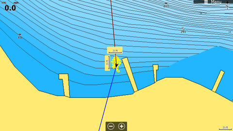
Ever wonder why your big boulder is in a different place than your waypoint at times? GPS can more accurate one day depending on satellites and weather and where your fish.
The boat is at my dock and I cleared the trail after the GPS locked in really good. This example is normal, I have repeated it many times and this was one of the most accurate examples. I did this one with Lowrance's point 1 GPS.
Your big boulder could move 25 feet on you while you were fishing it!

Creating waypoints on the water with your GPS is easy with 2 pushes of the waypoint button. But sometimes we have waypoints from maps, friends or secret sources that we want to enter in your GPS and they may be in degrees minutes

Read More >>
Technologically, fishing has come a long way. So, why should you be using GPS trails for fishing? That was my question for years of experimenting with the technologies available to learn.

Read More >>
Here are step by step instructions on how to save or transfer your waypoints with Lowrance Sonar

Read More >>
There are new choices when you save your waypoints from your Lowrance HDS GPS. This is an option on the LCX/LMS models and if you have updated previous models. You will notice you have a choice of saving them as Version 2 or Version 3. Version 2 is the same format as you have saved them in the past. Version 3 saves the depth when you saved the waypoint.
Read More >>
A common question at my classes is “Can I drive to a waypoint and find a small spot?”

Read More >>
I get many questions on how far is that fish or hump on the sonar screen behind the boat? This is difficult because it depends on chart speed and/or boat speed. I found an easy way using the sonar cursor to measure distance behind a boat.

Read More >>
Navionics downloadable improvements for their map chips and the Community Layer contains all edits made by Navionics users

Read More >>


